NGA
- North America
- Central, South America
- Western Africa, Mediterranean, Black Sea
- Eastern Africa, Southern Asia
- Australia, New Zealand, Indonesia, Papua New Guinea
- South Pacific Islands
- Eastern Asia, South Eastern Russia, Philippines
- Other Regions
Canadian
Caribbean and Mediterranean
Norwegian
SHOM
SEMAR
U.S.
Search by chart title, key word or chart number:
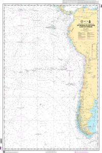
Nautical Chart SHOM6964
De Panama au Cap Horn (Cabo de Hornos)
Scale: 10000000
Actual Chart Size: 27.4" x 41.2"
Paper Size: 36.0" x 45.0"
Edition Year: 1994
Corrected Date: 2024-12-17
The chart you are viewing is a navigational chart by the Naval Hydrographic and Oceanographic Service.
©2025 Nautical Charts Online, All Rights Reserved.
- Alaska Coast
- Pacific Coast
- Atlantic Coast
- Great Lakes
- Gulf of Mexico
NOAA Nautical
Charts
- Hurricane
- Bathymetric
- Historical
- Training
- Canoe Charts
- Satellite Charts
- Placemats
Specialty Charts
- Chart Tubes
- Safety Whistle
Other Products
for Mariners
- Framed Charts
- Canvas Wraps
- Wall Murals
- Gallery


