

Shop by Region
NGA
- North America
- Central, South America
- Western Africa, Mediterranean, Black Sea
- Eastern Africa, Southern Asia
- Australia, New Zealand, Indonesia, Papua New Guinea
- South Pacific Islands
- Eastern Asia, South Eastern Russia, Philippines
- Other Regions
Canadian
Caribbean and Mediterranean
Norwegian
SHOM
SEMAR
U.S.
Search by chart title, key word or chart number:

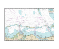
NOAA Nautical Chart 11428
Okeechobee Waterway St. Lucie Inlet to Fort Myers; Lake Okeechobee

Scale: 40,000
Actual Chart Size: 58.9" x 40.7"
Paper Size: 42.0" x 63.0"
NOAA Edition #: 37
NOAA Edition Date: 2015-11-01
OceanGrafix Edition #: 38*
OceanGrafix Edition Date: 2021-09-23*
NTM Notice/Date: 1424 2024-04-06
NTM: https://msi.nga.mil
LNM Notice/Date: 1324 2024-03-26
LNM: http://ocsdata.ncd.noaa.gov/nm
NTM = NGA Notice to Mariners
LNM = Local Notice to Mariners
*Under the guidance of NOAA's Office of Coast Survey, this chart has amassed enough critical and non-critical corrections such that OceanGrafix has issued a new edition number. This edition number now overrides the NOAA edition number. This chart contains all of the latest NOAA updates at the time of printing and is available for purchase online or from one of our retailers.
This chart has been canceled so it is NOT updated weekly and does NOT include all of the latest Notice to Mariners corrections. This chart is available for purchase online.
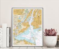
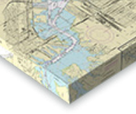
Turn Your Chart Into Art!
We now have five options for chart artwork that are perfect for home or office. Click on one of the options below to get started. We offer a variety of sizes and pricing.


©2024 Nautical Charts Online, All Rights Reserved.